Here are some nice hiking possibilities:
- Forbordfjellet using Våttåstien.
Våttåstien is an old path up to the top of Forbordsfjellet. Våttåstien was perhaps used to get up to the cairn at the top of Forbordsfjellet in the old days. About the cairn, you can read the following in the book Skatval Vår historiske arv bind IV: “…the oldest cairn was up the Svartberget where the dividing mark runs between Forbord and Skatval. Later it was moved to the northwest corner of the mountain so that it could be seen better from Innherred. The cairn was built of several logs surrounded by a stone wall. Inside, the cairn had a kind of tent room which was filled with small nails cut from pine roots. Outside there were more nails in a boat. The guardhouse (våttåstuggu) was about 5×3 cubits, and so high that a man could stand upright under the mønsåsen (1 cubit is approx. 63 cm). The living room had a door in the eastern cross wall and a viewing window in each of the other walls.” Furthermore, one can read that “…the cairn blew over in a storm in the late 1940s” (19th century) and in the Crane Era 1850-51 “the householders took and went home to burn both vaattaastuggu and spikes“.
The path is marked with signs. This is a summer trail, but it might be possible to walk in winter too depending on the amount of snow or ice. - Svartkamhytta.
The trip to the Svartkamhytta hut is an easy hike, approximate 2.5km from the dome. The hut is usually open every Sunday from 10:30 to 14:00. Waffles, coffee and juice are sold. Se this description for more info about the hike. In the winter it is preferable to do the trip using skies, but it is possible to walk also (take care not to destroy the ski-tracks). - Steinvikholm Castle is an island fortress on the Skatval peninsula. The castle was built over seven years, from 1525 to 1532, by Norway’s last Roman Catholic Archbishop, Olav Engelbrektsson. Steinvikholm castle became a powerful fortification by the time it was built, and it is the largest construction raised in the Norwegian middle age.
Read more about the castle in this Wikipedia article.


Summer tours in Koomot
Here are some possibilities for hiking in the summer or when it is no or little snow. The map is clickable and will take you to Koomot where all hikes can be downloaded as GPX or investigated more deeply. The dome is not marked on the map, but is near the center, a bit to the left.
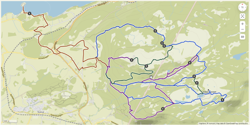
(https://www.komoot.com/collection/2545364/-forbord-dome-summer-tours)
Cross-country skiing possibilities in the winter:
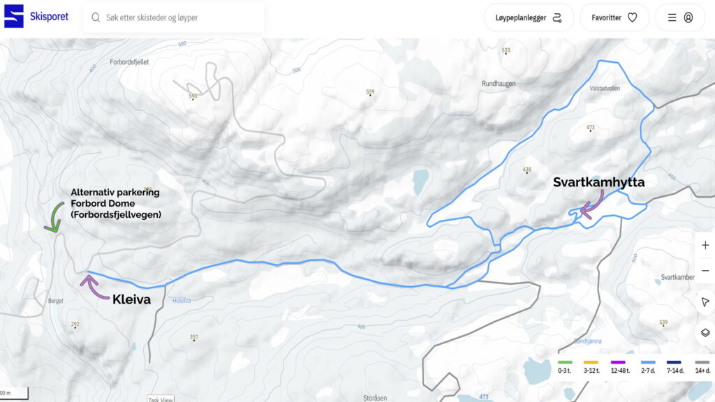
In the image above you can see some of the cross-country skiing trails available in the area. The blue line shows the cross country ski trail to Svartkamhytta. Svartkamhytta is an open and unattended cabin, with serving some Sundays. The starting point of the blue line (to the left in the image) is the parking area called “Kleiva”. This parking area are approximately 500m from the alternative parking area for Forbord Dome. Be aware of that the road to “Kleiva” (and the alternative parking for Forbord Dome) might be difficult in the winter due to snow and ice, so please take the necessary precautions, such as a car with four-wheel drive and/or and studded tyres. Do not hesitate to contact us for advice.
Recent Comments